The most comprehensive picture ever created of the Earth’s ever-changing surface will be possible from next month.
When the NASA-ISRO SAR satellite launches into orbit on July 30, it will ping nearly all of the planet’s land and ice surfaces with a form of imaging called synthetic aperture radar twice every 12 days.
Cornell University Professor Rowena Lohman will be one of the first people to monitor the satellite’s progress.
“The radar will capture ground movements as small as a centimeter, to create the most comprehensive picture yet of Earth’s ever-changing exterior,” Professor Lohman said.
“From forests and wetlands to mountain glaciers and sea ice, scientists will be able to better understand the causes and consequences of land surface changes, particularly as they relate to the global climate crisis.”
NASA has released a list of the five things you need to know about NISAR, which was a joint effort between NASA and the Indian Space Research Organization.
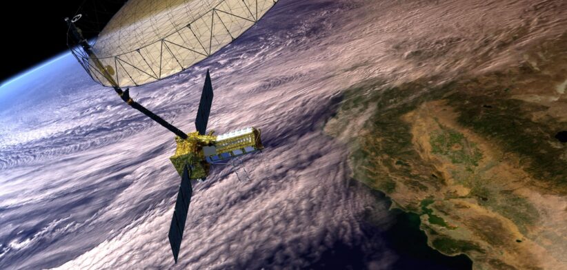
- The NISAR satellite will provide a 3D view of Earth’s land and ice.
Two synthetic aperture radars (SARs) aboard NISAR will detect changes in the planet’s surface down to fractions of an inch. The spacecraft will bounce microwave signals off Earth’s surface and receive the return signals on a radar antenna reflector measuring 12m across.
The satellite’s ability to “see” through clouds and light rain, day and night, will enable data users to continuously monitor earthquake- and landslide-prone areas and determine how quickly glaciers and ice sheets are changing. It also will offer unprecedented coverage of Antarctica, information that will help with studying how the continent’s ice sheet changes over time.
- Data from NISAR will provide critical insights to help governments and decision-makers plan for natural and human-caused hazards.
Earthquakes, volcanoes, and aging infrastructure can pose risks to lives and property. Able to see subtle changes in Earth’s surface, NISAR can help with hazard-monitoring efforts and potentially give decision-makers more time to prepare for a possible disaster.
For earthquakes, NISAR will provide insights into which parts of a fault slowly move without producing quakes and which are locked together and could potentially slip. The satellite will be able to monitor the area around thousands of volcanoes, detecting land movement that could be a precursor to an eruption. When it comes to infrastructure such as levees, aqueducts, and dams, NISAR data collected over time can help managers detect if nearby land motion could jeopardize key structures, and then assess the integrity of those facilities.
- The most advanced radar system ever launched as part of a NASA or ISRO mission, NISAR will generate more data on a daily basis than any previous Earth satellite from either agency.
About the length of a pickup truck, NISAR’s main body contains a dual-radar payload — an L-band system with a 25cm wavelength and an S-band system with a 10cm wavelength. Each system is sensitive to land and ice features of different sizes and specializes in detecting certain attributes, such as moisture content, surface roughness, and motion. By including both radars on one spacecraft — a first — NISAR will be more capable than previous SAR missions.
These two radars, one from NASA and one from ISRO, and the data they will produce, exemplify how collaboration between spacefaring allies can achieve more than either would alone. The radars will generate about 80 terabytes of data products per day over the course of NISAR’s prime mission. That’s roughly enough data to fill about 150 512-gigabyte hard drives each day. The information will be processed, stored, and distributed via the cloud — and accessible to all.
- The NISAR mission will help monitor ecosystems around the world.
The mission’s two radars will monitor Earth’s land and ice-covered surfaces twice every 12 days. Their near-comprehensive coverage will include areas not previously covered by other Earth-observing radar satellites with such frequency. The NISAR satellite’s L-band radar penetrates deep into forest canopies, providing insights into forest structure, while the S-band radar is ideal for monitoring crops. The NISAR data will help researchers assess how forests, wetlands, agricultural areas, and permafrost change over time.
- The NISAR mission marks the first collaboration between NASA and ISRO on a project of this scale and marks the next step in a long line of Earth-observing SAR missions.
The NISAR satellite features components developed on opposite sides of the planet by engineers from ISRO and NASA’s Jet Propulsion Laboratory working together. The S-band radar was built at ISRO’s Space Applications Centre in Ahmedabad, while JPL built the L-band radar in Southern California. After engineers from JPL and ISRO integrated NISAR’s instruments with a modified ISRO I3K spacecraft bus and tested the satellite, ISRO transported NISAR to Satish Dhawan Space Centre in May 2025 to prepare it for launch.
The SAR technique was invented in the U.S. in 1952 and now countries around the globe have SAR satellites for a variety of missions. NASA first used the technique with a space-based satellite in 1978 on the ocean-observing Seasat, which included the first spaceborne SAR instrument for scientific observations. In 2012, ISRO began launching SAR missions starting with Radar Imaging Satellite (RISAT-1), followed by RISAT-1A in 2022, to support a wide range of applications in India.