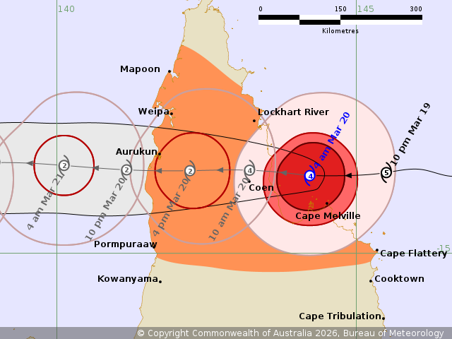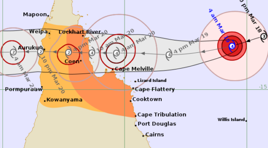
Severe Tropical Cyclone Narelle will bring very strong winds to Far North Queensland today (Friday) before moving towards the Northern Territory on Saturday.
Narelle is now a “very dangerous” Category 4 system with winds near the centre of 195 kilometres per hour and wind gusts to 270 kilometres per hour.
In a bulletin released this morning, the Bureau of Meteorology issued cyclone warnings for the following communities:
- Cape York Peninsula between Lockhart River and Cape Flattery
- Between Mapoon and Pormpuraaw, including Coen, Weipa, and Aurukun
There is also a “watch zone” from Nhulunbuy to Port McArthur, including Borroloola, Numbulwar, Alyangula, Ngukurr and Bulman.
“Narelle is forecast to move over Cape York Peninsula as a tropical cyclone during Friday while weakening,” the Bureau said.
“Narelle will then continue to move west across the Gulf of Carpentaria, and expected to strengthen again to a severe tropical cyclone before impacting the eastern Northern Territory from late Saturday.”
The Bureau has urged people in the cyclone areas to stay calm, remain in a secure shelter and stay above the expected water level.
“Do not venture outside if you find yourself in the eye of the cyclone – very destructive winds from a different direction could resume at any time,” it said.
“There may be powerlines down, broken glass and other hazards.”
The Bureau has issued the following hazard warnings:
Queensland
VERY DESTRUCTIVE WIND GUSTS in excess of 250 km/h are possible near the centre of Severe Tropical Cyclone Narelle as it crosses the Cape York Peninsula coast on Friday morning.
DESTRUCTIVE WIND GUSTS to 160 km/h are likely south of Lockhart River to north of Cape Flattery this morning.
DESTRUCTIVE WIND GUSTS are likely to persist near the centre of Narelle as it moves across Cape York Peninsula during Friday.
Gales with DAMAGING WIND GUSTS to 120 km/h are likely from Cape Flattery to north of Lockhart River.
Gales with DAMAGING WIND GUSTS to 120 km/h are also forecast to extend across Cape York Peninsula, including areas between Mapoon and Pormpuraaw, during Friday.
HEAVY RAINFALL which may lead to FLASH FLOODING with LOCALLY INTENSE RAINFALL is likely in an area of the Cape York Peninsula bounded by Lockhart River, Cape Flattery, Pormpuraaw, and Weipa during Friday.
Tides will be higher than normal between Coen and Cape Flattery as Narelle approaches and crosses the coast.
LARGE WAVES may produce MINOR FLOODING of low-lying coastal areas. There is a small risk that tides may approach the highest tide of the year during Friday. Tides in Princess Charlotte Bay are likely to rise significantly above the normal high tide, with DAMAGING WAVES and DANGEROUS FLOODING.
Any coastal residents in this area are specifically warned of a possible DANGEROUS STORM TIDE as the cyclone centre crosses the coast.
Once Narelle moves into the Gulf of Carpentaria, tides on the western Peninsula between Weipa and Kowanyama may be higher than normal.
LARGE WAVES may produce MINOR FLOODING of low-lying coastal areas.
Northern Territory
GALES are not expected in coastal areas in the next 24 hours, however gales are expected to develop in coastal areas between Port McArthur and Nhulunbuy from Saturday afternoon as Narelle approaches from the east, and extend inland to areas including Ngukurr on Saturday night or early Sunday morning.
VERY DESTRUCTIVE winds are possible near the centre of the cyclone on Saturday night.
HEAVY RAINFALL which may lead to FLASH FLOODING is possible for coastal and adjacent inland areas over the eastern Top End between Port McArthur and south of Nhulunbuy from late Saturday.
Tides will be higher than normal between Nhulunbuy and Port McArthur later Saturday and Sunday.
LARGE WAVES may produce MINOR FLOODING of low-lying coastal areas.
A potentially DANGEROUS STORM TIDE between Alyangula and Port Roper is possible as the cyclone centre crosses the coast with DAMAGING WAVES and DANGEROUS FLOODING.
For cyclone preparedness and safety advice, visit the Get Ready Queensland website www.getready.qld.gov.au
For non-life threatening emergency assistance contact State Emergency Services (SES) online via the SES Assistance QLD App, Apple , Android, online www.132500.qld.gov.au, or call 132 500 from anywhere in Queensland.