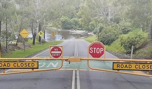
Residents of the Moreton Bay region north of Brisbane experienced widespread flash flooding on Thursday, October 22, after thunderstorms dumped more than 160 mm of rain in the region in three hours.
The City of Moreton Bay urged residents to avoid unnecessary travel and monitor emergency warnings as further heavy rainfall threatens the region.
The Bureau of Meteorology reported 168 mm of rainfall at Sheep Station Creek in Morayfield in the three hours to 7:30 am on Thursday, while several other locations recorded more than 140 mm.
The Bureau reported the following rainfall totals for Thursday:
- Morayfield: 168 mm at Sheep Station Creek in 3 hours to 7:30 am.
- Mt Reservoir: 163 mm in the 3 hours to 8:30 am.
- Elimbah: 159 mm at Rose Creek Rd in 3 hours to 8:12 am.
- Caboolture: 159 mm at Short St in 3 hours to 7:30 am.
- Burpengary: 141 mm at Mathew Cr in 3 hours to 7:45 am.
SEQ road closure information is here.
On Friday, October 23, the Bureau of Meteorology issued a series of flood and severe thunderstorm warnings across southern and western Queensland following heavy rainfall.
Sunshine Coast: An initial flood warning is in place for the Maroochy River, Coochin Creek and Mooloolah River catchments.
Stanley River: An initial minor flood warning has been issued for the catchment north-west of Brisbane.
Darling Downs: An initial minor flood warning is in place for the Upper Condamine River.
Western Queensland: Minor flood warnings remain current for the Warrego, Bulloo and Barcoo rivers.
Severe thunderstorms: A warning is current for parts of the Darling Downs and Granite Belt forecast district.
South-East Queensland: A severe thunderstorm warning has been cancelled for the Somerset, Scenic Rim, Southern Downs, Toowoomba, Lockyer Valley, Sunshine Coast and Moreton Bay council areas.
The Bureau is also forecasting further showers and possible thunderstorms across parts of southern Queensland, with the potential for additional heavy rainfall and localised flooding.
Road closures and emergency response
The City of Moreton Bay said on Thursday it was managing multiple weather-related road closures and responding to rapidly changing conditions across the region.
Council libraries are available for refuge, with details published on the Disaster Dashboard (see below).
Deputy Mayor Jodie Shipway urged residents to monitor official warnings and local emergency information.
“We’re also asking them to make sure they’re getting the latest information by checking Council’s Disaster Dashboard for local updates on severe weather, road closures, power outages and evacuation centres.
“I also urge people to sign up to severe weather warnings to receive Moreton Alert
“If there’s one thing people should be mindful if it’s if it’s flooded forget it!”
Residents urged to take precautions
Emergency services have advised residents to remain inside sturdy buildings during storms, avoid unnecessary driving and never attempt to cross floodwater.
Residents have also been urged to secure pets, charge mobile phones and power banks, close doors and windows and check on family, friends and neighbours.
People requiring urgent flood or storm assistance should contact the SES on 132 500.
To understand your risks and plan for severe weather season visit: https://www.moretonbay.qld.gov.au/Services/Disaster-Management
To understand your flood risk, download your flood check property report: https://www.moretonbay.qld.gov.au/Services/Property-Ownership/Flooding/Flood-Check
To sign-up for Moreton Alert, a free SMS, email and voice alert system providing severe weather warnings, bushfire warning messages and other important alerts visit: https://www.moretonbay.qld.gov.au/Services/Disaster-Management/MoretonAlerty
The City of Moreton Bay Disaster Dashboard can be accessed at https://disaster.moretonbay.qld.gov.au
The Bureau of Meteorology (BOM) is Australia’s official source of weather warnings. For more information on weather warnings visit: https://www.bom.gov.au