Severe Tropical Cyclone Narelle is expected to bring “severe impacts” to Far North Queensland by the end of the week.
This morning the Bureau of Meteorology issued a cyclone warning for areas between Lockhart River and Cape Tribulation, and a declared a “watch zone” from Kowanyama to Weipa.
Warnings are no longer current for Port Douglas, north of Cairns.
To monitor developments and warnings go to the BOM tracking site.
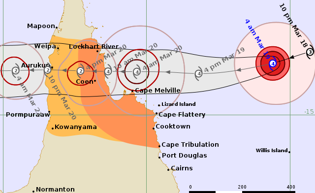
The Bureau has labelled Cyclone Narelle a category 4, with sustained winds near the centre of 165 kilometres per hour and wind gusts to 230 kilometres per hour.
This morning the cycle was sitting 515km northeast of Cooktown and 670 kilometres east of Coen, moving west southwest at 22 kilometres per hour.
“Narelle is moving steadily to the west and will approach the far northeast Queensland coast between Lockhart River and Cooktown,” The Bureau said.
“A severe impact is likely during Friday. After crossing the northeast Queensland coast, most likely on Friday morning, Narelle is forecast to continue tracking westwards.”
The Bureau said that after crossed the coast it was likely to temporarily weaken as it crossed Cape York Peninsula, but remain a tropical cyclone.
It was expected to impact the Northern Territory on the weekend.
The Bureau warned of the following hazards
- VERY DESTRUCTIVE WIND GUSTS in excess of 230 km/h are possible near the centre of Severe Tropical Cyclone Narelle as it crosses the coast.
- DESTRUCTIVE WIND GUSTS to 160 km/hr are likely from Lockhart River to Cape Flattery from Thursday night and may extend south to Cooktown if Narelle takes a more southerly path. DESTRUCTIVE WIND GUSTS are possible near the centre of Narelle as it moves further inland across Cape York Peninsula during Friday.
- Gales with DAMAGING WIND GUSTS to 120 km/hr are likely between Lockhart River and Cooktown from Thursday evening, and may extend south to Cape Tribulation if Narelle takes a more southerly path.
- Gales with DAMAGING WIND GUSTS to 120 km/hr will also possibly extend across Cape York Peninsula, including areas between Weipa and Kowanyama from Friday.
- HEAVY RAINFALL which may lead to FLASH FLOODING is possible between Cape Melville and Cape Tribulation from Thursday evening, extending northwards and to inland areas west of Coen during Friday. LOCALLY INTENSE RAINFALL is likely in an area of the Peninsula bounded by Lockhart River, Cape Flattery, Pormpuraaw, and Weipa during Friday.
- Tides will be higher than normal between Coen and Cape Tribulation as Narelle approaches and crosses the coast. LARGE WAVES may produce MINOR FLOODING of low-lying coastal areas. There is a small risk that tides may approach the highest tide of the year during Friday.
- Tides in Princess Charlotte Bay are likely to rise significantly above the normal high tide, with DAMAGING WAVES and DANGEROUS FLOODING. Any coastal residents in this area are specifically warned of a possible DANGEROUS STORM TIDE as the cyclone centre crosses the coast.
- Once Narelle moves into the Gulf of Carpentaria, tides on the western Peninsula between Weipa and Kowanyama may be higher than normal. LARGE WAVES may produce MINOR FLOODING of low-lying coastal areas.
People in the impacted areas have been urged to take precautions and keep listening to updated advice.
For cyclone preparedness and safety advice, visit the Get Ready Queensland website www.getready.qld.gov.au
For non-life threatening emergency assistance contact State Emergency Services (SES) online via the SES Assistance QLD App, Apple , Android, online www.132500.qld.gov.au, or call 132 500 from anywhere in Queensland.